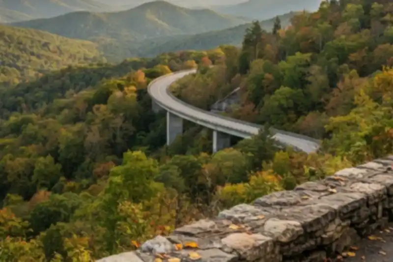
The Foothills Parkway is the Smokies drive that skips the traffic 🍂
Foothills Parkway is the best scenic drive in the Smoky Mountains that most visitors never take, and it starts twenty minutes from Pigeon Forge. It is a National Park Service road, it is free to drive, it has no billboards, no gas stations, no traffic lights and no towns, and on an October Saturday when Newfound Gap Road is a slow parade of brake lights, the Parkway is often close to empty. The reason is simple: it does not go anywhere. It runs along the ridges outside the park boundary, looking in, and then dumps you back on a highway. People who are trying to get somewhere skip it. People who want to look at mountains should not.
Here is the shape of it. Congress authorized a 72-mile parkway in 1944, and as of today only about 38 miles are open, in two disconnected pieces. The big one, Foothills Parkway West, runs 33 miles from Wears Valley down to US 129 at Chilhowee Lake, with a crossing of US 321 at Walland roughly in the middle. The small one, Foothills Parkway East, is a 5.6-mile hop between Cosby and I-40. The NPS itself calls it the oldest unfinished highway project in Tennessee, and the gap between Wears Valley and Cosby, which would pass behind Pigeon Forge and Gatlinburg, has no funding and no timeline.
That unfinished quality is why the road feels the way it does. For most of its length you are on a ridge crest with the main Smokies wall to the south and the Tennessee Valley to the north, and there are no side roads to get lost on. You get in at one end, you get out at the other, and in between you have somewhere between ten and thirty overlooks, depending on which stretch you choose.
This guide covers which section is worth your time, where to stop by milepost, the sunrise and sunset math that most write-ups get wrong, and the story of the 1.65 miles that took fifty years to finish.
Which section to drive, and where to stop
There are really three drives here, and they are not equal.
Walland to Wears Valley: the one to do first
This is the section that opened in November 2018, and it is the reason the Parkway went from local secret to bucket-list drive. The NPS puts it at 14.75 miles one way and it climbs to nearly 2,500 feet near Caylor Gap. From the Sevierville side, take Wears Valley Road (US 321) southwest out of Pigeon Forge for about ten miles; the entrance is on the left just past the Line Springs Road turn, signed for Foothills Parkway. Driven straight through it is about 25 minutes. With stops, budget an hour.
The overlooks, working from Wears Valley toward Walland, follow the NPS mileposts:
- Milepost 29 and 28: Wears Valley and Cove Mountain views. Milepost 28 has 10 spaces and looks across to Mount Le Conte and Roundtop. This is the “we just got here” stop, and it is good, but keep going.
- Between Mileposts 26 and 27, Caylor Gap: the main event. Two lots, 12 spaces in the main one and 5 parallel spaces in the second, a stone wall you can sit on, rolling hills to the west and the full Smokies wall to the south. Everything you have seen on Instagram from this road was taken here or within a mile of here.
- Near Milepost 25, Townsend Overlook: 10 spaces, views down into Tuckaleechee Cove and Townsend, the “peaceful side of the Smokies.”
- Between Mileposts 23 and 24: a mountainside pullout with a seasonal roadside waterfall. Only worth it after rain.
- Milepost 21, Capshaw Branch Overlook: the biggest lot on this stretch, 44 spaces plus 4 accessible. If Caylor Gap is full, this is your fallback.
- Milepost 18: 17 spaces with a view down to the Little River.
- Milepost 17: 4 spaces and a sidewalk to the welcome sign, at the Walland end.
The stretch between Caylor Gap and Wears Valley is where the bridges are. Nine of them carry the road across the steep gorge country of Bates Mountain and Carr Creek, and the one everyone photographs is the S-curved viaduct near the Wears Valley end. Heading east toward Wears Valley there is a small pullout, room for three or four cars, just before the S-curve. Park, cross the road on foot with care, and you get the postcard view of the bridge sweeping away into the mountains. Do not walk out onto the bridge itself. It is technically allowed, and it is a bad idea.
Walland to Chilhowee: the long, quiet original
Cross US 321 at Walland and the Parkway continues another 17 miles southwest along Chilhowee Mountain to US 129 at Chilhowee Lake. This half opened in 1966 and has four overlooks looking north into the Tennessee Valley and eight looking south into the Smokies. The star is Look Rock, at 2,650 feet the highest point on the whole road. The Look Rock Tower Trail leaves from the south side of the road between mileposts 14 and 15: a paved 0.8-mile round trip, steep in places, up to an observation tower with a 360-degree view that takes in Kuwohi and Thunderhead to the southeast, Le Conte to the east, McGhee Tyson Airport to the northwest and the Cumberland Plateau across the northern horizon. On the clearest days you can pick out the high peaks of the eastern Smokies.
Two practical notes on this half. First, the only restrooms on the entire Parkway are at the Look Rock Picnic Area, just off the road near the campground; there are none at the tower parking lot or trailhead. Second, if you drive all the way to the Chilhowee end you are 25 minutes from the nearest bathroom in Vonore, and the road you land on is US 129, which within a few miles becomes the Tail of the Dragon. That is a great motorcycle road and a terrible surprise if you are in a minivan with kids who need to stop.
Cosby to I-40: the 20-minute bonus
Foothills Parkway East is short, 5.6 miles, and it is a completely different landscape: Green Mountain, with English Mountain filling the western horizon and Mount Cammerer and the eastern Smokies to the south. It is worth doing if you are already out at Cosby (say, after a morning at Carver’s Orchard) or coming in from Asheville on I-40 and want to enter the region the pretty way. Use Exit 443. One warning from experience: if this section is closed, you will not find out until you have crossed the bridge over the interstate and reached the gate.
The part everyone gets wrong
The sunset math. Every listicle says “watch the sunset from Caylor Gap.” The sun in autumn sets behind the ridges to the west-southwest, and from a mountainside you never see the true horizon, so you lose the light 15 to 20 minutes before the published sunset time. Show up at the published sunset time and you have missed it. Arrive 45 minutes early, and pick a partly cloudy evening: those are the ones where the sky keeps burning after the sun is gone. Sunrise is the opposite problem. The Walland-to-Wears-Valley overlooks mostly face south and west, so they are sunset overlooks. For sunrise, drive the Walland-to-Chilhowee half, where the south-facing overlooks catch first light on the Smokies.
Google Maps will route you around it. Because the Parkway “goes nowhere,” navigation apps will never put you on it. If you type “Foothills Parkway” as a destination you will get a random point on the road. Set your destination as “Foothills Parkway Wears Valley entrance” or the Look Rock Tower trailhead, and once you are on the road, ignore the app until you reach the other end.
The parking tag applies here. This is national park land, so the Park it Forward tag rules apply: any stop over 15 minutes needs a tag, $5 a day, $15 a week or $40 a year. There are no kiosks on the Parkway. Buy the tag beforehand at Sugarlands or Cades Cove visitor centers, online at recreation.gov, or at the retailers around Townsend and Wears Valley. If you already bought one for Cades Cove, it covers you here too.
It is not a leaf-peeping shortcut to Cades Cove. People use the Parkway to reach Townsend and then Cades Cove, which works fine, but in late October Cades Cove Loop Road is its own two-to-four-hour commitment. If your goal is fall color with the least time in a line, the Parkway alone beats Cades Cove. The ridge sits in the 1,800 to 2,500 foot band, which typically peaks the third or fourth week of October (our leaf season in the Smoky Mountains post has the full elevation ladder), and you look across at every elevation band at once.
Do not treat it as a bike or walking path. It is a two-lane road with no shoulder, blind curves and a 45 mph limit, and no bike lane. Walk the overlooks and the Look Rock trail; leave the road to the cars.
There is nothing on it. No fuel, no food, no water, no cell signal for long stretches, and no restrooms except at Look Rock. Fill the tank in Pigeon Forge or Townsend and bring water. It is only 33 miles, but with kids and a dog and eight overlook stops it can eat an afternoon.
Why we drive it more than any other road here
Ariana and I came to Sevierville from Miami, where a “scenic drive” means the causeway to Key Biscayne, and the first fall we owned the cabin we did the obvious thing: Newfound Gap Road on a Saturday in October, which took two hours to go 30 miles. A neighbor told us to try the Parkway instead. We now take it a dozen times a year, and it is the one drive we send every guest to, because you cannot mess it up and it does not require a reservation, a lottery or a 6 AM alarm.
Our standard loop from the cabin is about two and a half hours with stops: out Wears Valley Road, onto the Parkway at the Wears Valley end, stop at Milepost 28, sit on the wall at Caylor Gap for as long as the light holds, continue to Walland, and either cross 321 and add Look Rock (add an hour) or turn toward Townsend for a late lunch before driving back through Wears Valley. Our dog rides the whole thing with her head out the window and is legal at every overlook, since pets are allowed on roads and in picnic areas, just not on the tower trail. If you are pointing the car toward the Parkway anyway, the Metcalf Bottoms back entrance we describe in our secluded cabin near Pigeon Forge guide makes an easy detour into the park proper.
It is also the drive we give guests who book Sunny Sierra Cabin directly and text us at 4 PM asking what to do before dinner: go now, bring a jacket, be at Caylor Gap by 6:15 in October, and do not trust the sunset time on your phone.
Quick reference
- Best single stretch: Wears Valley to Walland, 14.75 miles, about 25 minutes without stops, an hour with them.
- Best overlook: Caylor Gap, between Mileposts 26 and 27. Backup: Capshaw Branch at Milepost 21 (44 spaces).
- Best sunset: Caylor Gap, arrive 45 minutes before the published time. Best sunrise: the south-facing overlooks between Walland and Look Rock.
- The bridge photo: small pullout on the east side, just before the S-curve viaduct near Wears Valley. Cross the road on foot; do not walk the bridge.
- Look Rock Tower: 0.8 miles round trip, paved, steep, no dogs, trailhead between Mileposts 14 and 15. Highest point on the road at 2,650 feet.
- Restrooms: Look Rock Picnic Area only. Nearest at the Wears Valley end is Metcalf Bottoms Picnic Area inside the park.
- Cost: free to drive; a Park it Forward tag ($5/$15/$40) for any stop over 15 minutes, purchased beforehand since there are no kiosks on the Parkway.
- Vehicle limits: none. RVs and trailers are fine on the road, but several overlooks (Caylor Gap’s second lot, the bridge pullout, Milepost 22) will not fit them.
- Fall color timing: third to fourth week of October for the ridge itself; the road looks at every elevation at once, so mid-October through early November all work.
- Current conditions: the NPS closures page listed no Foothills Parkway closures as of mid-September 2026, but the road has closed for paving in past years, so check before a long drive.
The Parkway will not be finished in our lifetimes, and that is fine. The unfinished road is the good road. Drive it before everyone else figures that out.
Sources
- Foothills Parkway overview — National Park Service
- Drive Foothills Parkway (Walland to Wears Valley) — National Park Service
- Hike to Look Rock Tower — National Park Service
- Current Cautions and Closures — Great Smoky Mountains National Park
- Complete Guide to the Foothills Parkway — Road Trips & Coffee
- Foothills Parkway — Wikipedia